Geography
At Bloxwich Primary Academy, our primary aspirations in Geography are to install both an awareness and appreciation of the nature of the subject and foster a sense of curiosity and fascination towards it.

Intent
At Bloxwich Primary Academy, our primary aspirations in Geography are to install both an awareness and appreciation of the nature of the subject and foster a sense of curiosity and fascination towards it. Through high quality first teaching - utilising specialist knowledge and a range of resources - we intend to equip our children with knowledge and understanding of diverse places, people and both the natural and human environments that surround them.
We intend to provide children with a deep understanding of the Earth’s key physical and human processes, helping to ensure that they can have a key role in ensuring the well-being of it. Our curriculum builds progressively using Cornerstones to enable our children to develop essential geographic knowledge and skills - which are transferable and allow our children to clearly understand the relationship between Geography and other areas of the curriculum. Expectations are high for all children and they are given opportunities to challenge themselves, learn without limits and develop curious, inquiring minds.
What do our lessons look like?
Typical planning and lessons would include:
1) Retrieval activities or questioning to recall prior learning with a varied amount of time with having to recall from - last week’s learning, last term’s learning, last year’s learning.
2) Clear explanations of the learning question through the use of the MYLO.
Teachers discuss the learning objective with key things in mind:
Why are we learning about this objective?
How are we going to learn about this objective?
How does this fit into our current learning journey?
3) Review session with ‘what can you recall…’ questioning
This will be based on any prior learning that links into the lesson. This is where an opportunity to recall any key vocabulary and recap meaning fits too. This helps to develop our children’s use of language.
4) Main Activities
When planning history lessons, staff consider how the following things can be included to ensure all learners can achieve the desired objective:
- Is the work adapted to suit the needs of all children?
This could be through scaffolding, additional resources, visual supports, varied task or support.
- Does the work provide children with a suitable amount of challenge? or Is there room to add a challenge to deepen understanding and encourage higher order thinking?
- Does the work answer the learning question introduced at the beginning of the lesson?
6) Each year group completes an ‘Innovation Day’ as well as an end of unit ‘big write’ to answer the key question they have been focusing on for the term and demonstrate learning are carried out.
In EYFS pupils will explore geographical themes through a child-centred approach based upon the topics covered through Cornerstones. Our children will be encouraged to develop a sense of their physical world as well as their community, and provided with opportunities to explore, observe and find out about people, places and the environment around them.
The Primary National Curriculum for Geography is split into 4 key parts, with different specific aims included within each:
- Locational knowledge
- Place knowledge
- Human and physical geography
- Geographical skills and fieldwork
- Name and locate the world’s seven continents and five oceans
- Name, locate and identify characteristics of the four countries and capital cities of the United Kingdom and its surrounding seas
- Understand geographical similarities and differences through studying the human and physical geography of a small area of the United Kingdom, and of a small area in a contrasting non-European country
- Identify seasonal and daily weather patterns in the United Kingdom and the location of hot and cold areas of the world in relation to the equator and the north and south poles
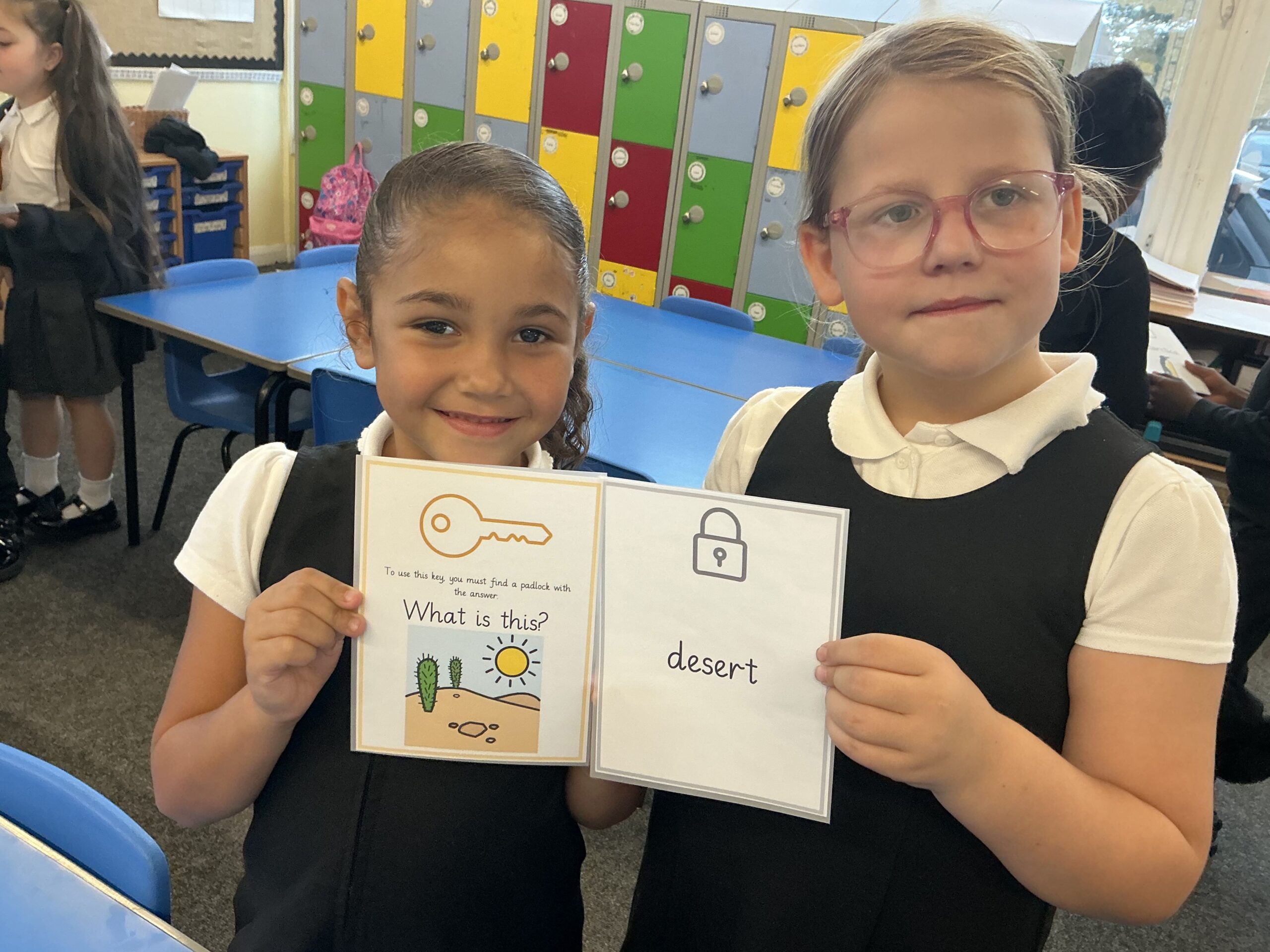
- Use basic geographical vocabulary to refer to key physical features, including beach, cliff, coast, forest, hill, mountain, sea, ocean, river, soil, valley, vegetation, season and weather
- Use basic geographical vocabulary to refer to key human features, including city, town, village, factory, farm, house, office, port, harbour and shop
- Use world maps, atlases and globes to identify the United Kingdom and its countries, as well as the countries, continents and oceans studied at this key stage
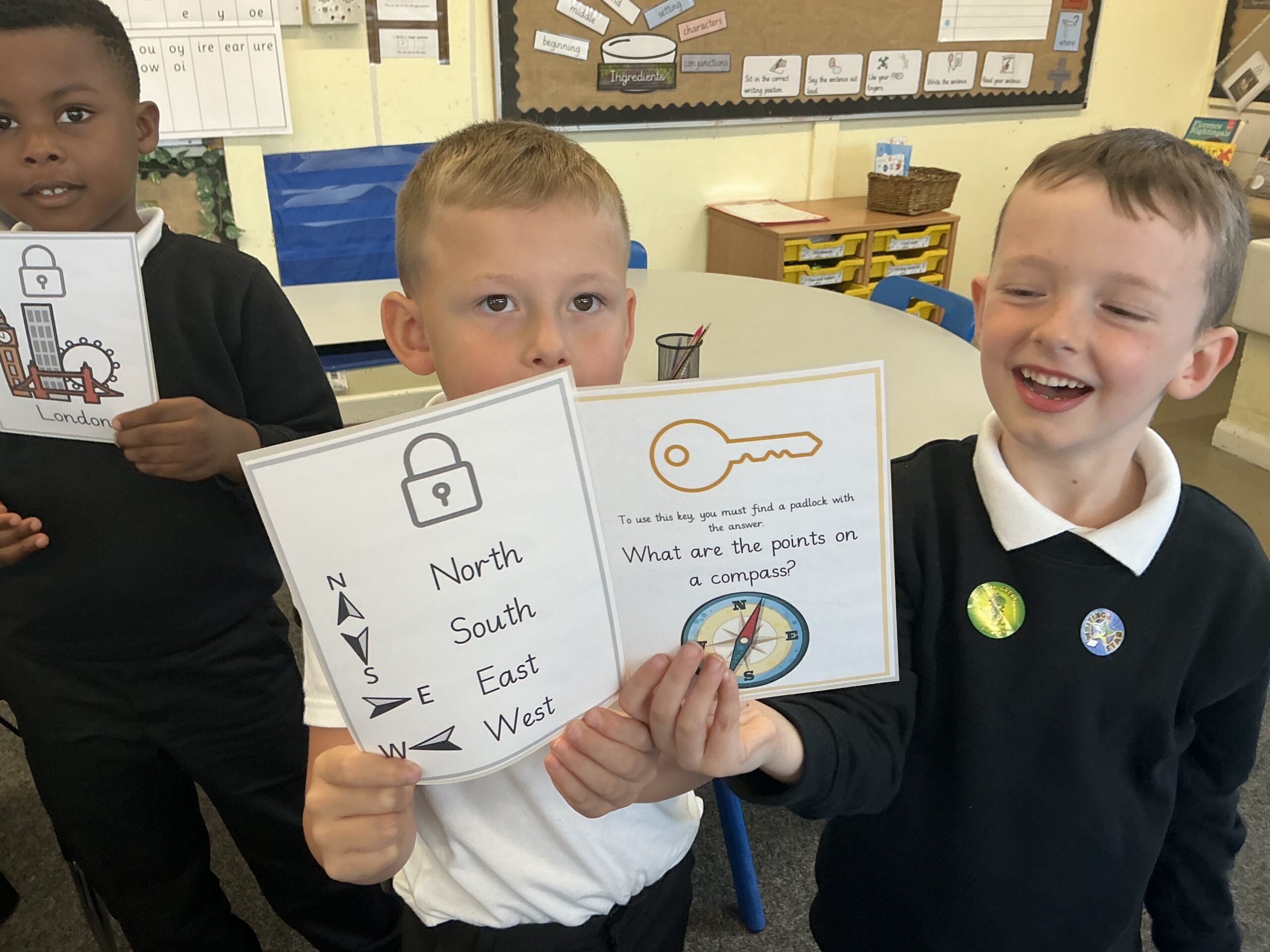
- Use simple compass directions (north, south, east and west) and locational and directional language [for example, near and far; left and right], to describe the location of features and routes on a map
- Use aerial photographs and plan perspectives to recognise landmarks and basic human and physical features; devise a simple map; and use and construct basic symbols in a key
- Use simple fieldwork and observational skills to study the geography of their school and its grounds and the key human and physical features of its surrounding environment.
- Locate the world’s countries, using maps to focus on Europe (including the location of Russia) and north and South America, concentrating on their environmental regions, key physical and human characteristics, countries, and major cities
- Name and locate counties and cities of the United Kingdom, geographical regions and their identifying human and physical characteristics, key topographical features (including hills, mountains, coasts and rivers), and land-use patterns; and understand how some of these aspects have changed over time.
- Identify the position and significance of latitude, longitude, equator, northern hemisphere, southern hemisphere, the tropics of cancer and Capricorn, Arctic and Antarctic circle, the prime/Greenwich meridian and time zones (including day and night).
- Understand geographical similarities and differences through the study of human and physical geography of a region of the United Kingdom, a region in a European country, and a region within North or South America
- Describe and understand key aspects of physical geography, including climate zones, biomes and vegetation belts, rivers, mountains, volcanoes and earthquakes, and the water cycle
- Describe and understand key aspects of human geography, including types of settlement and land use, economic activity including trade links, and the distribution of natural resources including energy, food, minerals and water
- Use maps, atlases, globes and digital/computer mapping to locate countries and describe features studied
- Use the eight points of a compass, four and six-figure grid references, symbols and key (including the use of ordnance survey maps) to build their knowledge of the United Kingdom and the wider world
- Use fieldwork to observe, measure, record and present the human and physical features in the local area using a range of methods, including sketch maps, plans and graphs, and digital technologies.